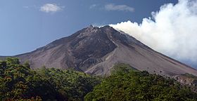
| Mount Merapi | |
|---|---|
| Gunung Merapi | |
 Merapi, July 2005 | |
| Elevation | 2,968 m (9,738 ft) |
| Prominence | 1,392 m (4,567 ft) |
| Listing | Ribu |
| Translation | Mountain of Fire (Indonesian) |
| Location | |
| Coordinates | 7°32′26.99″S 110°26′41.34″E / 7.5408306°S 110.4448167°ECoordinates: 7°32′26.99″S 110°26′41.34″E / 7.5408306°S 110.4448167°E |
| Geology | |
| Type | Active Stratovolcano |
| Age of rock | 400,000 years |
| Last eruption | 30 November 2010 |
The name Merapi could be loosely translated as 'Mountain of Fire'. The etymology of the name came from Meru-Api; from the Javanese combined words; Meru means "mountain" refer to mythical mountain of Gods in Hinduism, and api means "fire". Smoke can be seen emerging from the mountaintop at least 300 days a year, and several eruptions have caused fatalities. Hot gas from a large explosion killed 27 people on 22 November in 1994, mostly in the town of Muntilan, west of the volcano. Another large eruption occurred in 2006, shortly before the Yogyakarta earthquake. In light of the hazards that Merapi poses to populated areas, it has been designated as one of the Decade Volcanoes.
On 25 October 2010 the Indonesian government raised the alert for Mount Merapi to its highest level and warned villagers in threatened areas to move to safer ground. People living within a 20 km (12.5 mile) zone were told to evacuate. Officials said about 500 volcanic earthquakes had been recorded on the mountain over the weekend of 23–24 October, and that the magma had risen to about 1 kilometre (3,300 ft) below the surface due to the seismic activity. On the afternoon of 25 October 2010 Mount Merapi erupted lava from its southern and southeastern slopes.
The mountain was still erupting on 30 November 2010 however due to lowered eruptive activity on 3 December 2010 the official alert status was reduced to level 3.


0 comments:
Post a Comment